
Weather risk that used to be a gut feel is now a data-backed report.
WeatherWise Contingency gives construction planners and project managers access to a decade of historical weather data for any location worldwide. Search your site, select the nearest monitoring station, and generate clear reports for planning workshops, float calculations, and EOT delay claims, all from the browser.
Data-driven insights for weather-sensitive planning
Global Location Search
Search any project address or GPS coordinate worldwide, WeatherWise identifies the nearest official monitoring station automatically.
Nearest-Station Mapping
Automatically selects and maps to the closest official weather station, ensuring the data is representative of your actual site conditions.
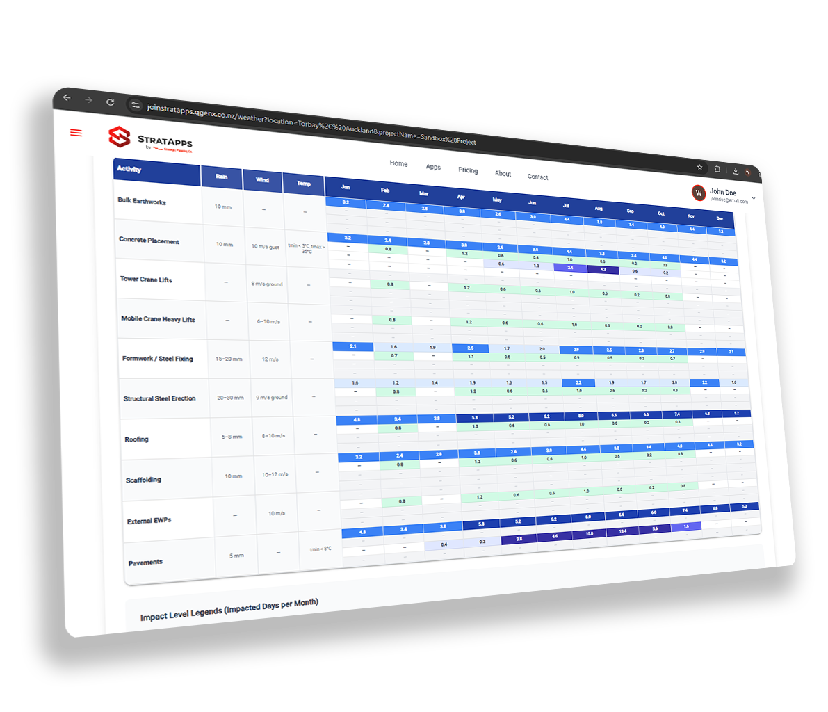
10-Year Historical Analysis
Rain days, temperature ranges, wind speeds, and seasonal patterns, averaged across a full decade of recorded data.
Monthly Risk Calendar
At-a-glance seasonal risk table, see which months carry the highest weather risk for outdoor construction activities.
Planning-Ready Reports
Export clean, formatted reports designed for use in risk workshops, planning sessions, and EOT substantiation packages.
Defensible & Auditable
All data is sourced from official monitoring stations, giving your weather contingency reports the credibility needed for contractual and claims contexts.
Where WeatherWise makes the difference
Float & Contingency Planning
Quantify weather-related float requirements for outdoor activities, backed by real historical data rather than rule-of-thumb estimates.
EOT & Delay Claims
Support extension of time claims with a clear, data-backed record of historical rain days and weather events at the project site.
Risk Workshop Inputs
Bring objective weather risk data into planning workshops, enabling teams to make informed decisions about programme buffers and seasonal risks.
From location to report in three steps
Search your project location
Enter your project address, town, or GPS coordinates. WeatherWise maps to the nearest official monitoring station.
Analyse 10 years of data
The app retrieves and processes a decade of historical weather records, rain days, temperature, and wind by month.
Download your report
Export a formatted weather contingency report, ready for programme reviews, risk workshops, or contract submissions.
Why this beats everything else
Guesswork and gut feel
Weather contingency is often a flat percentage pulled from experience, with no real data to support it.
Manual research
Pulling historical weather records from NIWA or BOM is time-consuming and requires specialist interpretation.
Indefensible in disputes
Rough contingency figures get challenged in EOT claims because there's no documented methodology behind them.
10 years of location-specific data
Real historical records from the nearest monitoring station, not a broad national average or rough estimate.
Automated in seconds
No manual data pulls. Enter your location and the app retrieves and processes everything automatically.
Audit-ready report
A formatted report with source data, methodology, and monthly breakdown, defensible in any forum or claim.
Weather contingency shouldn't be a guess. Now it doesn't have to be.
For every team that builds outdoors
Analyse your project's weather risk today
Register for free on the StratApps platform, no credit card required.